HISTORY OF ORANGE
etc., where he now lives, bounded on all sides by the highway." So it looks as if the house was built in the fall of 1720.
The story is that during the erection of the house, the Indians watched so attentively that a guard was set to watch them. On March 26, 1707, John Rogers deeded Joseph Rogers fifty acres at High Plains, and again on March 15, 1717, twelve more acres in the same locality, namely the plain extending south from the Orange church, on the westerly side of the highway.
How many dwellings were erected in the southern part of what is now Orange in the early years of the eighteenth century does not definitely appear, but it would seem that the number must have been considerable, as indicated by the vote of the Town of Milford in 1750, referred to by Mr. Barber, ''that money be appropriated to set up a school at Bryan's Farms, it being populated enough that one is deemed necessary.''
In a Town Meeting, April 25, 1721, a committee was appointed to lay out the present Oggs Meadow Road. As reported by this committee, this layout began on the ''north line of the 'First Purchase' '' and extended southerly on the western side of the Wepawaug River to a point where the Derby Turnpike is now located, and turned eastward to join a road that came down from the Race, between the 2nd and 3rd Shots. (Just what was meant by the Shots is hard to tell. One old meaning of a shot was a corner or plot of land.) However, need of a formally laid-out highway indicates that there were dwellings on or near it.
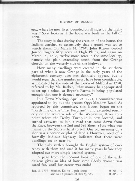
The early settlers brought the English system of currency with them and used it for many years before they adopted our more simple decimal system.
A page from the account book of one of the early citizens gives an idea of how some elderly woman was cared for, until her career was ended:
Jan. 15, 1757 Mother, Dr. to 1 pair shoes 0 - 05 - 0
also to 12 pounds of flax @ 5 1/2 0 - 05 - 6